

- Leli Hesti Indriyati, M.KK – darimedia.id
There is always a first time for everything, including this trip. For me, this was my first hike in Japan.
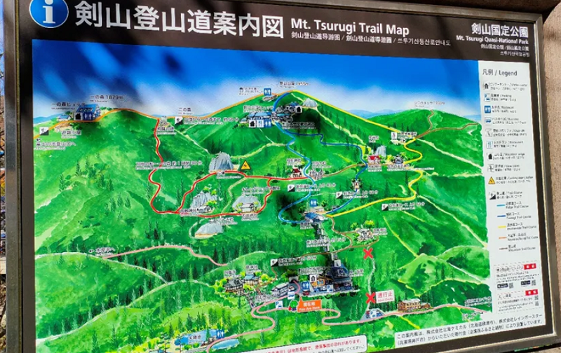
With an elevation of around 1955 meters, Mount Tsurugi is one of the “100 Famous Mountains in Japan”. It is Shikoku Island’s second highest mountain, located at the remote eastern end of Iya Valley.
I was so excited from the start of the trip that morning, even though it was a bit nervous because I didn’t know what kind of terrain to climb here.
I had already imagined my body being crushed, as it had been the day before when I was climbing Mount Gede in Indonesia within 1 day. When we were climbing mountains in Indonesia, we would usually spend at least two days or more and we will over stay in the mountains before summiting to the peak in the early morning.
Tsurugi-san is located on the border of Kochi and Tokushima, and it took nearly 3 hours to get there from Kochi that morning.It’s a narrow and winding road, as is typical of mountain roads, but with fall already in full swing, it’s a visual feast.
Despite the fact that it is quite high, don’t worry since there is a quick way to get there by taking the chair lift from Minokoshi to Nishijima.
I thought it was a cable car like the ones on Sidosima Island in Kagawa or the Senkoji Ropeway in Onomichi (Hiroshima), but it’s totally different.
It’s actually shaped like a chair, and each chair can only hold one person. You can then go up, but not until the peak. With fares of around 1050 for adults, 520 for children (one way) and 1900 for adults, 900 for children (round trip), it appears to be a reasonable price to reach the summit without difficulty.
To get to the top, we’ll have to walk for another 1–2 hours, depending on each person’s walking speed. This method, of course, saves a lot of time and energy. No wonder that I encountered many elderly hikers or families with children.


How about us?
Of course, we felt strong and rejected the idea of taking the chairlift.
So we decided to trek to the top from the starting point.
Actually, the terrain isn’t too difficult, though there are a few climbs here and there..So ,honestly when I saw the chair lift passing by, how come I was a little sorry huh? Hahha…:-D
I think it would be nice to go up using the tool, then walk a little more to get to the top..but of course we can’t stop the chairlift in the middle of the road …So inevitably I continued this climbing journey with my friends.Fortunately, they were all fun and the scenery around us was beautiful because the fall season had already started …
We arrived at the same point as the last chair lift after nearly 2.5 hours of walking… And everyone had to walk up to the top.
Again, the terrain wasn’t too difficult…it was just that the incline felt steeper than the initial journey. But in some places a path has been made like a staircase which makes our trip easier.
As in some other places in Japan, it is very common to find shrines/temples including here. And not just temples, even here we can find places where we can buy prophecy written on a piece of paper…The funny thing is that if the results do not match expectations, then the paper can be left there …
And what’s more interesting is that there is a wooden stairway to the summit! It’s neatly arranged, neat and very helpful for those who enjoy heights.
It’s definitely different when I summit in Indonesian mountains to get to the top.Usually the summit trip is one of the toughest and challenging trips, but not for this trip in Japan!
So it didn’t feel like a summit, but just a walk to the next village! Hahaha
Japan is a champion for making everything comfortable for everyone…so how could they think of making this wooden staircase path to the top!
Perhaps there are more difficult trips on different trails on this mountain that I am unaware of.
Not only did we find the stairs, but we also discovered a small house at the summit that was either inhabited or not…both of these things add another dimension to Mt Tsurugi’s allure.
The fact that we could see the clouds in front of us added to the epic ending to the afternoon trip. When the weather is clear, we can see the Kii peninsula and Okayama prefecture on the other side of the Seto Inland Sea from the top.
We passed the time by having lunch together and, of course, taking pictures..Oh yes, it gets colder up here…so it is still recommended to bring warm clothes if you want to go up to the top.
We were very lucky because on the way back and forth from the summit the weather was quite favorable…sometimes in Japan, it can rain in any season, including winter!
I’m glad we made it back to our starting point safely and we completed this trip without missing anything.
In my opinion, this trail is suitable for beginners and can be completed in 1 day,
Oh, and don’t forget about the breathtaking scenery! On the right, left, front, and back, we were treated to trees, twigs, and leaves whose colors had turned yellowish…some even red…while others remained green… Very lovely!


